Diving the Cape Peninsula and False Bay: Two Coastlines, 300-Plus Sites
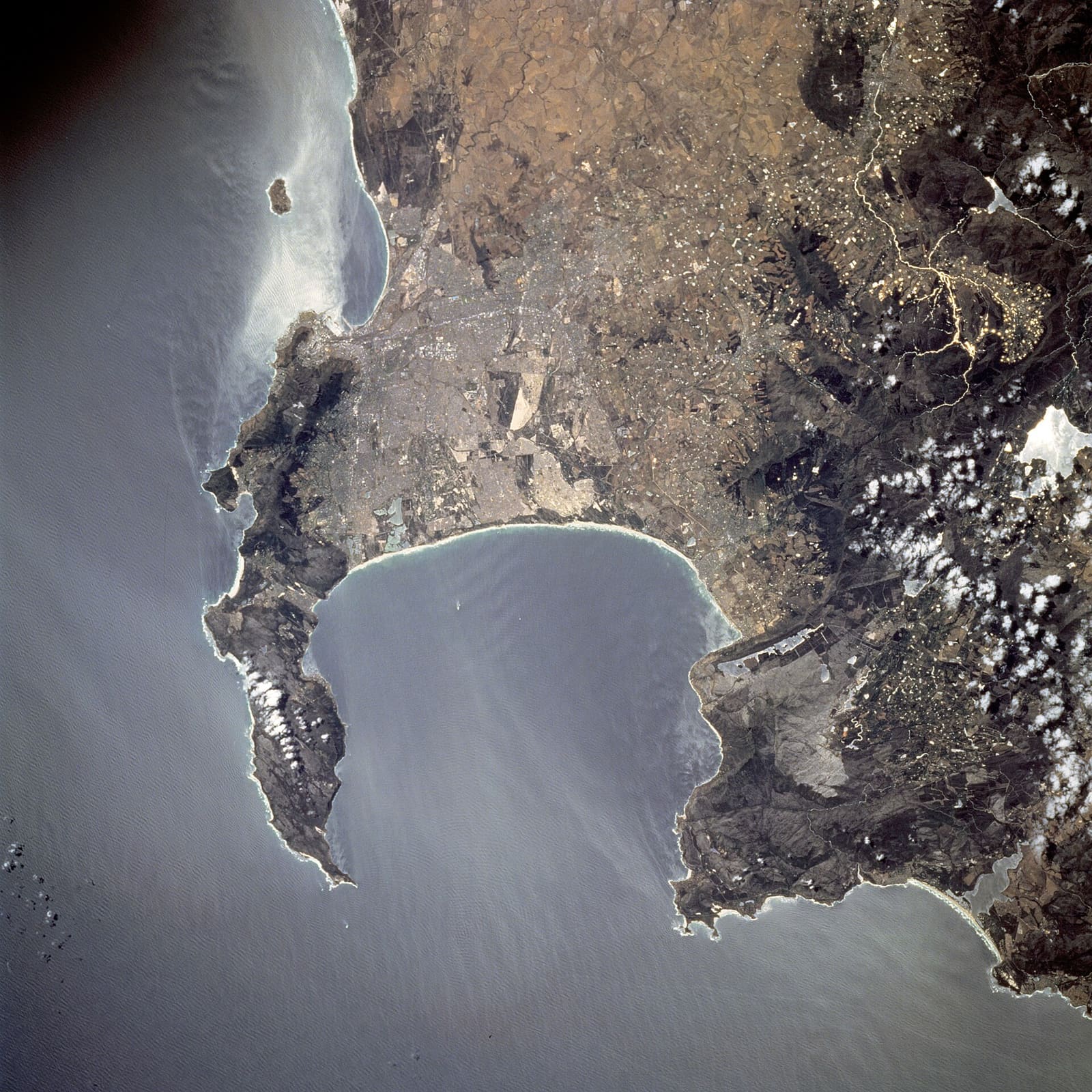
Most dive destinations sell you one coastline. Cape Town gives you two, and they behave like different countries.
On one side of a narrow mountain spine you have the Atlantic seaboard. On the other, False Bay. When the summer south-easter is howling across one, it is blowing offshore on the other. That single fact is why divers here rarely cancel a weekend outright. They just drive.
And there is plenty to drive to. The regional guide records over 300 named dive sites with positions, all within a day trip by road from any part of greater Cape Town. That is a lot of sites for one destination, and the reason people spend years here without running out.
How the region fits together
The Cape Peninsula is a narrow mountainous strip, at most 11 km wide and just over 50 km long, running south from the city to Cape Point. Table Mountain stands at 1,085 m at the northern end. Further south, Swartkop rises to 678 m near Simon's Town. The slopes are steep almost the whole way, with very little flat ground at the coast.
North of the city is Table Bay, a big open bay with Robben Island in its mouth. West is the Atlantic coast, ragged, with a string of small bays and one large one at Hout Bay about halfway down.
East of the peninsula is False Bay. Roughly square in plan, about 30 km across each way, 1,090 km² in area, with an average depth around 40 m and roughly 80 m at the centre of its mouth. The bottom is generally smooth and slopes gently from north to south, muddiest in the middle.
Down the western shore you pass Smitswinkel Bay, Simon's Bay and Fish Hoek Bay. At Muizenberg the coast goes low and sandy and swings east to Gordon's Bay, then turns south along the foot of the Hottentots Holland range to Cape Hangklip, almost the same latitude as Cape Point. Kogelberg, at 1,269 m, is the high point on that side.
Reefs, rocks and one island
The reefs here are old landforms that got flooded. During the ice ages they stood above sea level, and the granite was shaped for far longer by groundwater working along tectonic joints, rounding corners and cutting deep crevices and gullies. When the ice melted and the sea rose, the shapes simply went under. What you swim over now is a drowned landscape of corestones and tors.
The standout feature in False Bay is Whittle Rock, an underwater granite hill about 1 km across that rises from sand at roughly 40 m to within 5 m of the surface. Several smaller, deeper granite reefs lie nearby. Outside the bay sits Rocky Bank, a large sandstone reef with 20 to 30 m over the top, falling away to deeper than 100 m on its southern side.
There is one true island in the bay: Seal Island, a bare granite outcrop about 200 m long, roughly 2 ha in area, less than 10 m above the water at its highest point, about 6 km south of Strandfontein. A scattering of islets and shoals make up the rest.
Worth knowing about the maps: the SURGMAP bathymetric charts were made by swimming the contours towing a GPS buoy, usually accurate to within a couple of metres. They are reliable for what they show, but seldom complete, and some tall pinnacles may simply never have been found. The regional dive guide is refreshingly honest about that.
Seasons, wind and water
This is a Mediterranean climate, not the summer-rainfall pattern of the rest of South Africa. Rain comes in winter, June to September, on eastward-moving frontal systems that arrive from the north-west and then swing to south-westerly as the front passes. That south-westerly swell is the signature of winter, hitting the Atlantic coast and the eastern side of False Bay.
Summer belongs to the south-easterly wind, which circulates off the Atlantic High and can blow for days under clear skies. False Bay faces south, so it takes that wind, especially on its western side. Table Bay, the peninsula's west coast, and the stretch from Gordon's Bay to Cape Hangklip get it offshore instead.
Local variation is extreme and genuinely hard to believe. Gale force in Gordon's Bay, sweltering and windless 10 km away in parts of Somerset West. Rain on the peninsula in the morning, over the far side of the bay by afternoon.
There is even a climate-scale angle. In an El Niño year you can expect less strong south-easterly wind, and therefore less upwelling off the peninsula, which tends to mean relatively better diving conditions in False Bay. La Niña generally brings wetter conditions from December to February.
Simon van der Stel worked the wind out long before anyone dived here. He chose Simon's Bay as the winter anchorage for the Dutch East India Company's ships because the peninsula mountains shelter the western side of False Bay from the south-westerly wind and the south-westerly waves. Table Bay, meanwhile, has swallowed ships in winter storms for centuries.
| Month | Sea temperature (°C) | Wave height (m) |
|---|---|---|
| January | 18 | 1.9 |
| February | 18 | 1.7 |
| March | 18 | 1.8 |
| April | 18 | 2.2 |
| May | 17 | 2.0 |
| June | 15 | 1.9 |
| July | 14 | 1.8 |
| August | 15 | 1.8 |
| September | 15 | 2.0 |
| October | 16 | 2.1 |
| November | 17 | 1.8 |
| December | 17 | 1.7 |
The modelled monthly figures tell a simple story: warmest water around February to April at about 18 °C, coldest in July at roughly 14 °C, and wave height sitting between 1.7 and 2.2 m all year. Numbers like these are averages, though, and on this coast the average rarely describes the day you get.
Planning it
Base yourself anywhere in greater Cape Town and the whole region is reachable by road in a day. Simon's Town sits right in the middle of the False Bay side. Hout Bay puts you halfway down the Atlantic coast. Individual site write-ups in the guide range from a sentence to a small thesis, depending on what anyone has bothered to record.
Which is where you come in. Log your dives on Whittle Rock and note the depth you found over the pinnacle, add photos of the granite gullies, and rate the Atlantic and False Bay sites side by side so the next visitor knows which side to drive to. Start your Cape log at Scubaspot.