The Gulf of Kutch: India's Coral Reefs at the Edge of the Desert
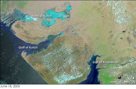
Most divers heading to India think south. Lakshadweep, the Andamans, maybe Goa. Almost nobody thinks of Gujarat.
But on the northwest coast, between the Kutch and Saurashtra peninsulas, there is a gulf with fringing reefs, platform reefs, patch reefs and coral pinnacles. Some of those coral clusters are thousands of years old.
One survey of the protected waters recorded 1,127 species of fauna and flora. That is the number worth repeating. This is a reef system at the edge of a desert coast, and it exists in a place where you would not expect to find one.
The shape of the gulf
The Gulf of Kutch opens onto the Arabian Sea, facing the Gulf of Oman. It is about 50 km wide at the mouth, then narrows inland into marshland, creeks and inlets, running roughly 150 km before giving way to an 8,500 square kilometre delta.
The two sides are very different. The south coast is the one divers care about: islands, mud flats and coral reefs. The north is lined with extensive mud flats, the biggest lying between Mundra and Kuvay, and most of the shipping harbours sit there too, including Mandvi, Bedi and Kandla.
Maximum depth in the gulf is around 123 m. At the mouth there is a scatter of shoals with wonderful names: Lushington, Ranwara, Bobby and Gurur.
Rainfall into the gulf is low and no major rivers feed it, so there is no big seasonal river run-off the way there is on much of the Indian coast.
A gulf that has been noticed for two thousand years
The Periplus of the Erythraean Sea, a sailor's travelogue written around 50 CE, mentions this water. It called it the Gulf of Baraca. Not many dive destinations come with a Roman-era name attached.
The Marine National Park and Sanctuary
Because so much life concentrates here, large sections have been set aside as parks and sanctuaries. The Gulf of Kutch Marine National Park and Sanctuary was established in 1980, the first of its kind in India, covering the islands strung along the Saurashtra coast.
The numbers give you a sense of the scale. The MNPS takes in 148.92 square kilometres across 42 islands plus 309 square kilometres of intertidal zone, of which 162.89 square kilometres is National Park. Under the Wild Life Protection Act of 1972, no human intrusion is permitted in park areas, while sanctuary areas allow certain rights such as fishing.
Coral reefs and mangroves were not originally covered. They were brought in under the 1991 Coastal Zone Regulation Notification.
Pirotan island is the one tourists reach. A 1994 management plan proposed restricting it to scientific research only, but visitor numbers kept climbing and the plan was never implemented. Between 2006 and 2007, seven thousand tourists set foot on the island. Tourism and education programs here are run by the Gujarat Ecological Education Research Foundation.
What lives down there
Reports on the hard corals vary: at least 37 species by one count, 44 by another, plus 12 species of soft coral. The youngest coral clusters, at Salaya, are 5,240 years old, and growth runs somewhere between 1 and 10 cm a year.
The broader species list from the protected area includes 200 molluscs, three species of turtle and three marine mammals, with other studies logging hundreds of fish species.
- At least 37 species of hard coral, possibly 44
- 12 species of soft coral
- 200 species of mollusc
- Three species of turtle
- Three species of marine mammal
- 1,127 species of fauna and flora recorded overall
The reefs have had a rough century. Satellite data showed total reef cover shrinking 43 percent between 1975 and 1986, a loss of nearly 100 square kilometres, caused by sediment smothering the coral and cutting off sunlight. The sediment came from coral dredging by a nearby cement company.
Bans near protected areas followed, and reefs grew back between 1985 and 1991, though industrial growth in the gulf has them declining again, as the Wikipedia entry on the gulf lays out.
Mangroves fared worse. Only 140 of 665.9 square kilometres sit under MNPS control. Industrial building between 1960 and 1980 cut freshwater supply, pushing Rhizophora and Ceriops into endangered status and taking at least one species to extinction. Recent gains are concentrated in Jamnagar and Kutch districts.
Water temperature through the year
| Month | Sea temperature (°C) | Wave height (m) |
|---|---|---|
| January | 22 | 0.4 |
| February | 22 | 0.3 |
| March | 25 | 0.4 |
| April | 27 | 0.5 |
| May | 30 | 0.7 |
| June | 31 | 0.8 |
| July | 30 | 1.0 |
| August | 29 | 0.9 |
| September | 29 | 0.7 |
| October | 28 | 0.4 |
| November | 27 | 0.3 |
| December | 24 | 0.3 |
The swing is wide for a tropical latitude: about nine degrees between February and June. Wave heights stay modest, peaking around a metre in July and settling to 0.3 m through late autumn and winter.
Tides and traffic
This is a big-tide gulf. Spring tides peak around 6.2 m and the annual average sits near 4 m, with the range growing the further in you go. Okha has been measured at 3.06 m while Kandla showed 5.89 m at the same moment. Current speeds run 1.5 to 2.5 knots at the entrance and 3 to 5 knots in the centre.
There is also a lot of shipping. In 2012 a vessel traffic service opened here, one of the largest in the world, covering 16,500 square kilometres and stretching about 800 km from Koteshwar to Okha. Nine radars, three repeater stations, six port monitoring stations, master control at Kandla. It cost ₹165 crore.
Planning a look
Pirotan is the island with an established visitor route, and GEER handles tourism and education access. Beyond that, this is a working industrial coast with ports at Mandvi, Bedi and Kandla on the northern shore, and the reefs on the southern side among those 42 islands.
If you get out to the Saurashtra islands, log the dive and put a number on what you actually saw: which corals, whether you spotted a turtle, how the visibility behaved on your tide. Records from this gulf are thin, and yours would stand out. Start a log at Scubaspot and add your photos of the pinnacles.