St Kilda, Scotland: a drowned volcano 35 miles past the Hebrides
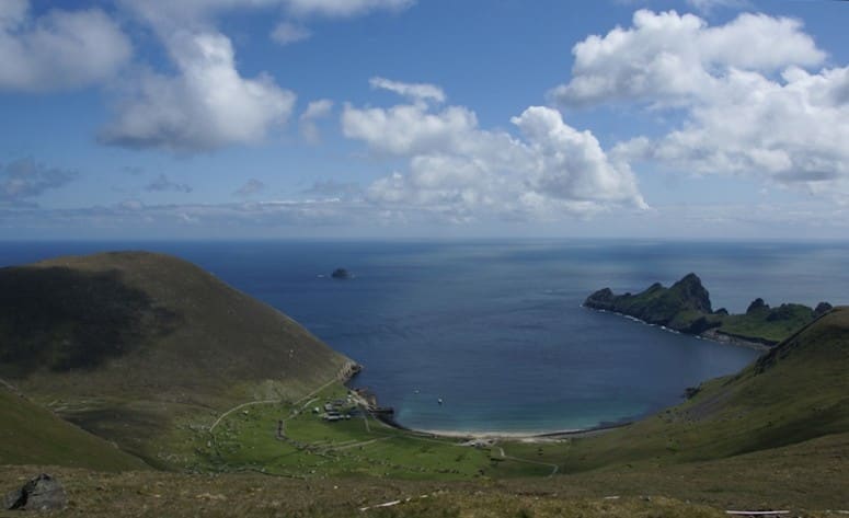
The whole archipelago is the leftover of a long-extinct ring volcano. It rises from a seabed plateau about 40 metres below the surface, and the granite and gabbro that make it up have been chewed by Atlantic weather for a very long time.
Above water that means the highest sea cliffs in the United Kingdom. The north face of Conachair is vertical for up to 427 metres and drops straight into the sea.
St Kilda is 35 nautical miles west-northwest of North Uist, the westernmost scrap of the Outer Hebrides. Nobody has lived there permanently since 1930. That combination of distance, rock and silence is the whole reason to go.
The islands, one by one
Hirta is the big one at 670 hectares, more than 78 percent of the land in the group. Village Bay sits on its east side, with the old settlement curled behind it and high hills in a semicircle. The approach makes it look gentle. It is not.
Dùn shelters Village Bay from the prevailing southwesterlies. It was once joined to Hirta by a natural arch. One story has a galleon fleeing the Spanish Armada knocking it down; other accounts say a winter storm simply took it.
Soay, the sheep island, lies 500 metres northwest of Hirta and reaches 378 metres. Boreray is six kilometres northeast and climbs to 384 metres. Both are smaller than Hirta but just as steep.
Then the stacks. Stac an Armin stands 196 metres out of the water and Stac Lee 172 metres, the two highest sea stacks in Britain. Stac Levenish, the smallest of the named ones, takes its name from a word for a stream or torrent, which tells you something about the water around it.
Weather, swell and the Atlantic
The climate is oceanic: 1,400 millimetres of rain a year, high humidity, cool temperatures averaging 5.6 °C in January and 11.8 °C in July. Snow lies about a dozen days a year. Winds are southerly and southwesterly, averaging 13 km/h roughly 85 percent of the time, with gusts over the high tops that regularly top 185 km/h.
The tidal range is 2.9 metres. Five-metre ocean swells are common, and they can make landing difficult or impossible at any time of year. Boats run in summer for a reason.
| Month | Sea temperature (°C) | Wave height (m) |
|---|---|---|
| January | 10 | 4.4 |
| February | 9 | 4.1 |
| March | 10 | 6.7 |
| April | 10 | 3.7 |
| May | 11 | 2.7 |
| June | 12 | 2.6 |
| July | 14 | 2.1 |
| August | 15 | 2.2 |
| September | 13 | 4.4 |
| October | 13 | 4.2 |
| November | 12 | 4.3 |
| December | 11 | 5.1 |
Read the wave column before the temperature column. The water hovers between 9 and 15 °C all year, so the difference between a trip that happens and one that does not is swell. July and August sit around 2.1 and 2.2 metres; March modelling runs to 6.7. The Open-Meteo marine data makes the summer window obvious.
Birds, sheep and small endemics
St Kilda is a breeding ground for northern gannets, Atlantic puffins and northern fulmars. You will hear them before you see the islands properly, and the stacks are white with them.
On land, two ancient sheep types survive here: the Soay, a Neolithic type, and the Boreray, from the Iron Age. There is also a St Kilda wren and a St Kilda field mouse, both endemic subspecies found nowhere else.
The village and the evacuation
People lived here for two millennia or more, probably never more than 180 of them. The peak came in the late 17th century. The medieval village on Hirta was rebuilt in the 19th century, then illness carried in by visiting ships and the upheaval of the First World War wore the community down.
By 1930 there were 36 residents left, and they were evacuated. Today the only year-round presence is military personnel, with conservation workers, volunteers and scientists in summer.
Look for the cleitean: stone storage huts unique to these islands. There are 1,260 on Hirta alone and another 170 across the rest of the group. They are part of why St Kilda became a World Heritage Site in 1986 under both natural and cultural criteria, a rare double.
Planning a trip
The archipelago is owned by the National Trust for Scotland and administered through Comhairle nan Eilean Siar. Total land area is 8.5 square kilometres. Your crossing starts from the Outer Hebrides and covers 65 kilometres of open Atlantic, so build your plan around a weather window rather than a date.
If you make the crossing, log it in Scubaspot with the stack or wall you dropped on, note the depth where the plateau levels off, and add a photo of Stac an Armin from the boat on the way out. Your buddies planning next summer's window will want the entry. Start at scubaspot.co.